WIIP: An Approach for Leveraging Geological Data Heterogeneity through Customization of Open-Source Software
Research data is continuously generated across various scientific and engineering disciplines, leading to diverse data types and sizes. As a result, the data becomes increasingly heterogeneous, posing challenges for interdisciplinary researchers to fully comprehend and exploit it wisely. The challenges arise due to the lack of comprehensive metadata, inconsistent methodologies, and non-unified terminologies. Herein, a Web-based Interactive Integrated Platform (WIIP) is proposed to facilitate the effective utilization of geological data from diverse fields of study.
The WIIP consists of a forum, a data control, and a data protocol system that enables continuous communication, data repository, and recording/revision of data acquisition procedures. The WIIP concept is currently under development on selected open-source software, but other alternative software options are available for exploration. Each selected software was designed to accomplish a specific task, but the integration with other software is minimal. While understanding diverse research data necessitates isolation within a dedicated data repository, the true value lies in integrating and leveraging such data. With the WIIP, interaction, and integration are the main aspects.
Through forums, researchers with various backgrounds openly discuss their datasets and answer related questions. At the same time, they share the protocols for data acquisition and clarify the terminologies used. In the data control (data repository), the data is managed and stored with essential metadata. By harnessing the power of open-source software, the WIIP approach supports unparalleled customization options and benefits from the collective support of open-source communities. It represents a sustainable solution for enhancing the comprehension and utilization of data heterogeneity, fostering efficient collaboration, and driving meaningful discoveries across disciplines. The WIIP system needs robust spatiotemporal visualization and comprehensive explanations for terminologies. Integration with interactive geological maps, a lexicon platform, and a unified user access/database system would greatly enhance the user experience and data contextualization.
Introduction
Research data is continuously generated across various scientific and engineering disciplines, leading to a diverse range of data types and sizes. As a result, the data becomes increasingly heterogeneous (i.e., 1 2), posing challenges for interdisciplinary researchers to comprehend it fully and exploit it wisely.
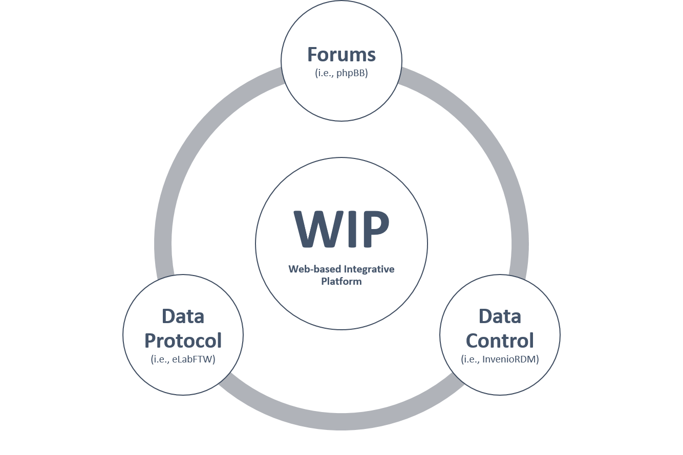
The challenges arise due to the lack of comprehensive metadata, inconsistent methodologies, and non-unified terminologies. Herein, a Web-based Interactive Integrated Platform (WIIP) is proposed to facilitate the effective utilization of geological data from diverse fields of study. The WIIP consists of a forum, a data control, and a data protocol system that enables continuous communication, data repository, and recording/revision of data acquisition procedures, respectively (Figure 1).
The WIIP concept is currently under development on selected open-source software (Figure 1), but there are other alternative software options available for exploration. Each of the selected software was basically designed to accomplish a specific task, but the implementation of integration with other software is minimal. While understanding diverse research data necessitates its isolation within a dedicated data repository, the true value lies in integrating and leveraging such data. With the WIIP, the interaction and integration are main aspects. Through forums, researchers with various backgrounds openly discuss their datasets and answer related questions. At the same time, they share the protocols for data acquisition and clarify the terminologies used. In the data control (data repository), the data is managed and stored with essential metadata . By harnessing the power of open-source software, the WIIP approach supports unparalleled customization options and benefits from the collective support of open-source communities. It represents a sustainable solution for enhancing the comprehension and utilization of data heterogeneity, fostering efficient collaboration, and driving meaningful discoveries across disciplines.
Methodology
We use three open-source software applications to illustrate the WIIP concept. These freely available tools can be customized and installed on local, secure servers. Specifically, we utilize phpBB 3.3.11 3 for the forum, InvenioRDM v11.0 4 for the data repository, and elabFTW 5.0.4 5 for the data protocol system.
However, it is important to note that they are not unique solutions, and each one has its own limitations. A detailed comparison between the selected software or the alternative options is beyond the scope of this work, as many authors have already published extensive evaluations (i.e., 6, 7). The key benefits of this WIIP approach are the unparalleled customization options and the collective support from open-source communities. This sustainable solution enhances the comprehension and utilization of data heterogeneity, fosters efficient collaboration, and drives meaningful discoveries across disciplines.
Results and Conclusions
The WIIP cyclic workflow consists of three components: the forum, data repository, and data protocol (Figure 1). It is accomplished through collaborative work, and each one is important from various perspectives. The forum aims to foster a vibrant, collaborative environment where individuals from diverse disciplines can come together to share their ideas, knowledge, and insights, resulting in a final output that integrates diverse perspectives. It provides a dynamic space that not only facilitates the exchange of ideas but also encourages interdisciplinary collaboration and innovation. It enables individuals to explore novel connections, bridge gaps between different fields, and gain a more comprehensive understanding of complex topics, including geological data management and protocols. By fostering an inclusive community, the forum empowers individuals at all stages of their intellectual development, enabling them to collaborate, learn from each other, and contribute to the collective growth of the geoscience community.
Data control is essential for effectively managing and storing geological data. It allows for a comprehensive evaluation, seamless reuse, and strategic exploitation of data, which is key for maximizing its values. Additionally, it enables the identification of gaps in existing data, allowing researchers to strategically collect new information to fill those critical knowledge gaps, and saves considerable time and resources, ultimately reducing the overall costs associated with geological studies and explorations.
Implementing the data protocol system to meticulously document and standardize data acquisition procedures is also crucial for several reasons. Firstly, it promotes consistency in data collection across different methods and projects, ensuring that information is gathered in a rigorously standardized manner. This consistency is vital for enabling reproducibility of results, as future studies can replicate the original data acquisition processes. Furthermore, a centralized digital system facilitates the seamless integration of data from multiple sources, allowing for a more comprehensive and cohesive analysis. Importantly, the data protocol system also helps to control and maintain the highest quality of data by establishing clear, unambiguous protocols and guidelines. Along with improving data integrity, this system can be leveraged for training purposes, transferring institutional knowledge, and onboarding researchers.
The WIIP system currently lacks key functionalities that could enhance its overall effectiveness, such as robust spatiotemporal visualization and comprehensive contextual explanations of used terminologies. Integrating the WIIP with interactive geological maps, a lexicon platform, and a unified user access/database system could greatly improve user experience and data contextualization. While open-source communities have helped resolve issues, addressing these remaining gaps would strengthen the WIIP as a comprehensive, user-friendly platform fostering collaboration and innovation in the geoscience domain.
Cite this post
If you found this post helpful, please consider citing it:
Alqubalee, A. (2025, April 8). WIIP: An Approach for Leveraging Geological Data Heterogeneity through Customization of Open-Source Software. ALQUBALEE Notes. https://qubalee.github.io/posts/2025/04/wiip/
References
Druskat, S., Bertuch, O., Juckeland, G., Knodel, O., & Schlauch, T. (2022). Software publications with rich metadata: state-of-the-art, automated workflows, and HERMES concept. arXiv preprint arXiv:2201.09015. ↩︎
Musyaffa, F. A., Rapp, K., & Gohlke, H. (2023). LISTER: Semiautomatic Metadata Extraction from Annotated Experiment Documentation in eLabFTW. Journal of Chemical Information and Modeling, 63(20), 6224-6238. ↩︎
phpBB (2024). phpBB • Free and Open Source Forum Software. Retrieved May 21, 2024, from https://www.phpbb.com/ ↩︎
InvenioRDM (2024). Turn-key research data management repository. Retrieved May 21, 2024, from https://inveniordm.docs.cern.ch/ ↩︎
elabFTW (2024). Open source laboratory notebook. Retrieved May 21, 2024, from https://www.elabftw.net/ ↩︎
Boch, M., Gindl, S., Barnett, A., Margetis, G., Mireles, V., Adamakis, E., & Knoth, P. (2022). A systematic review of data management platforms. In World Conference on Information Systems and Technologies (pp. 15-24). Cham: Springer International Publishing. ↩︎
Stall, S., Martone, M. E., Chandramouliswaran, I., Federer, L., Gautier, J., Gibson, J., Hahnel, M., Larkin, J., Pfeiffer, N., Sedora, B., Sim, I., Smith, T., Van Gulick, A. E., Walker, E., Wood, J., Zaringhalam, M., & Zigoni, A. (2023). Generalist Repository Comparison Chart (3.0). Zenodo. https://doi.org/10.5281/zenodo.7946938 ↩︎